Frequently Asked Questions

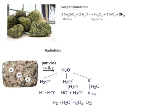
Unlike manufactured green hydrogen, natural hydrogen has a geological origin, being constantly replenished from water-rock interaction in deep geological formations. Several water-rock interaction processes producing molecular hydrogen have been identified, and although debate is still on going about the predominancy of each process, three sources have been regarded as most likely: i) serpentinization (reaction of water with iron-rich rocks); ii) natural radiolysis of water due to radioactive decay of U, Th, K rich minerals; iii) mantle degassing, in the vicinity of deep faults or rifting systems. It is possible that different mechanisms are involved simultaneously.

Thus, at the human scale, natural hydrogen is constantly being renewed, being a truly clean source of energy, unlike manufactured green or blue hydrogen.

It is based on the integration of an energy storage system and geological storage of CO2. The CO2 captured in a power plant or industrial facility is used as a working fluid in a thermodynamic cycle to store renewable (wind or solar) electrical energy underground. The storage of energy occurs in mechanical (work) and thermal (heat) forms.

The technique is similar to compressed air energy storage (CAES). However, unlike CAES it requires porous media geological reservoirs and when using CO2 instead of air, there are some added advantages: improved working fluid properties (low supercritical temperature and moderate pressure), lateral migration (definitive CO2 sequestration is a), fewer geological constraints (migration or residual CO2 capture functions as a strength for the technique), CO2 thermosiphon effects which reduces the cost of injecting and producing CO2 in the wells, and some (minor) geothermal heat extraction to mechanical energy storage.

see Carro, Chacartegui, Ortiz, Carneiro and Becerra (2022) for further details.

Experience with CO2 injection in geological formations, dates back to 1972, when the oil industry began utilising CO2 for enhancing hydrocarbon production. However, the first project of storage of CO2 in geological formations specifically implemented for climate mitigation purposes was launched in 1996, the Sleipner project in the North Sea, and since then about 1 million tonnes CO2 per year from the natural gas is captured and stored at Sleipner. Currently many more CO2 storage projects are ongoing, with the Global CCS Institute in its 2021 assessment indicating that 21 facilities are capturing 36.6 million tonnes of CO2 per year for geological storage and that a further 62 facilities are in construction or advanced development, with an added capture capacity of nearly 40 million tonnes of CO2 per year.

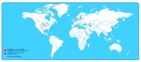
World map of CCS facilities at various stages of development (Global CCS Institute, 2021)

GPR is a general term applied to a radio wave methodology to delineate buried structures in the ground (natural or man-made).
The typical radio frequencies range from a few MHz to about 1000 MHz. The first uses of radio waves employed radio echo sounders to map the thickness of ice sheets and glaciers in Antarctica and in the Arctic.
The early 1970s mark the start of using GPR in non-ice environments. These days, GPR is being used in many areas such as locating buried utilities, mine site evaluation, forensic investigations, archaeology, searching for buried landmines and unexploded ordnance, and also measuring snow and ice thickness.

A GPR system transmits a small pulse of electromagnetic energy via an antenna (the transmitter) into the ground and records the time it takes for some or all of that energy to be returned to another antenna (the receiver), along with a measure of its signal strength.
The antennas are placed on (or very near to the surface of) the ground and moved across it to scan the area.
The transmitting pulses and the associated returns are recorded and allow composing an image (called radargram) of the subsurface.
Changes in the pattern of radargrams can be a result of changes in the ground’s mineral and water content, changes in the bedrock or soil, and objects such as archaeological artifacts or buried utility lines.
Unlike other geophysical methods, GPR is capable of mapping subsurface features with different compositions such as wood, stone, plastic and metal and giving their actual depth in the ground, what makes it an ideal tool for the studying of archaeological, environmental, and construction sites.
CONVERGE has the equipment and the expertise to perform GPR surveys in archaeological sites that are expected to be excavated or under archaeological investigation for locating old man-made artifacts.

Electrical resistivity tomography (ERT) is an electrical geophysical technique used for mapping the ground’s subsurface electrical resistivity by making measurements on the ground surface.
Electrical resistivity is a physical property that describes how difficult an electrical current goes through a certain material.
The ERT method is quickly emerging as a powerful means of obtaining subsurface geology, hydrogeology, and archaeology information.

In the ERT technique a DC electrical current is introduced into the ground with two electrodes and the electrical potential drop across the surface of the ground is measured between two other electrodes also stuck into the ground.
The surface electrical potential drop measurements provide information about the electrical resistivity of materials below the earth’s surface.
The depth of investigation of the ERT technique depends on the distance between the electrodes used to introduce the electrical current in the ground: the larger the distance the deeper the depth of investigation.
ERT profiles are produced by modeling the data from a series of measurements at different depths and locations along a survey line. Nowadays ERT data are quickly collected using an automated multi-electrode resistivity meter.
ERT profiles provide a great deal of information about the different materials in the subsurface.
CONVERGE has the equipment and the expertise to perform ERT surveys for obtaining geology information and studying archaeological, environmental, and construction sites.